Maps are a common feature of archival collections, and the Wheaton College Billy Graham Center Archives is no exception. The Archives’ oversize storage cases contain a wide variety of maps—thematic, navigational, topographical, and even blueprints—used for diverse range of research topics and as a popular tool in archival instruction sessions. As primary sources, maps require a specific set of skills to “read” and interpret. Like all items held in the Archives, maps are social documents, reflecting both the intentions and abilities of their creators (cartographers) as well as the needs and expectations of their anticipated users. Maps tell stories. While a single map can capture a landscape, metropolitan grid, or continent frozen in time, a series of maps can document gradual or abrupt change, like shifting national or regional boundaries, erosion of natural landmarks, or rapid urbanization. No map, however extensive or detailed, can be entirely authoritative. They are not neutral documents—maps reveal the political and cultural perspectives and biases of their creators. They can erase as well as document borders, languages, people groups, or landmarks. Finally, maps are frequently described in purely functional terms, providing information and direction to users, but in many cases they are also highly ornamental, utilizing artistic techniques to feature specific geographical or topographical features.
This month, the Archives commemorates 125 years of Africa Inland Mission (AIM) and traces its development in East Africa through a series of maps held in Collection 81: Records of Africa Inland Mission. Created by AIM staff and missionaries, these items overwhelmingly reflect the perspectives of Western missionaries and the European colonial powers that occupied the African continent in the twentieth century. The maps featured below tell an incomplete story—spanning only seven of the thirteen decades that Africa Inland Mission has operated in East Africa—but they do begin to suggest the stories behind the ink, images, and text, and illustrate the growth of the African church and the lives of missionaries who served there.
Africa Inland Mission launched its ministry in 1895 when Peter Cameron Scott, a Scottish Presbyterian, led a party of six other missionaries to enter the Kenyan interior from Mombasa, Kenya on the Indian Ocean coast. While AIM’s earliest work centered on Kenya, the mission’s focus quickly shifted to other regions and countries in East Africa, including German East Africa (1909, most recently Tanzania), Belgian Congo (1912, most recently Democratic Republic of Congo), Uganda (1918), French Equatorial Africa (1924, most recently Central African Republic), Sudan (briefly in 1949), Comoros Islands (1975), and the Seychelles Islands (late 1970s).
The six maps featured here span the transition from Africa’s colonial period at the turn of the twentieth century to the late-1970s, documenting the expansion of AIM’s work and identifying mission stations it established. These maps are part of the extensive collection of AIM records at the Archives, which also includes correspondence, reports, photographs, audio tapes and much more that document the mission’s history and activity and the emergence of the national church and its evangelists, leaders and pastors.
Kijabe Mission Station, circa 1908
The item featured below is the oldest AIM map held in the Archives, a vivid, hand-painted depiction of the mission station in Kijabe, Kenya, dating between 1907 and 1909. The map also documents a seminal period in AIM history: the consolidation of AIM missionary service in Kenya.
When AIM founder Peter Cameron Scott died partially from exhaustion in 1886, only a year after landing in Mombasa, the fledgling missionary enterprise nearly dissolved. Many AIM missionaries returned home or died on the field within their first year of service due to the strain of overwork, disease, or overexposure to the harsh climate. In the following year, AIM’s supporting body, the Philadelphia Missionary Council, took on greater oversight of the crumbling mission agency and appointed Charles Hurlburt as the new director. A gifted administrator, Hurlburt provided strong leadership for Africa Inland Mission and established the mission’s headquarters at Kijabe in 1903.
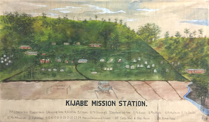
This vibrantly-colored map is likely one of the earliest representations of the AIM headquarters. Along the bottom of the painting is a key, indicating the nature of the various buildings and sites in the painting. The key is incomplete or unclear however—some of the numbers do not appear on any buildings, and some of buildings have no numbers. A close examination of the painting also shows some numbers have been partially erased.

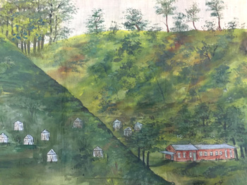
The map illustrates the remarkable growth of the Kijabe station in its first decade, including a chapel, orphanage, and separate houses for AIM staff members. The large red building in the center of the painting was likely the home of Charles Hurlburt, the leader of the station and the entire mission for more than three decades (Hurlburt’s personnel file is available in Collection 81, Box 47, Folder 22). Details captured in this map offer a glimpse into the daily activities of the Kijabe station—the mission’s expansive gardens conveniently located next to the river, the well-worn paths to the football fields, or the sizable cattle shed sandwiched between the two. The Kijabe brick kiln identified on the map is likely responsible for producing the station’s red-colored buildings.
Beside Hurlburt, the individuals mentioned in the key are Lee H. Downing, Fred H. McKenrick, Josephine Hope, John R. Riebes and Ernest Devin. Except for Devin, all the people mentioned were significant leaders in the history of AIM. Josephine Hope was the founder of Rift Valley Academy, where generations of AIM missionary kids were educated. All the staff listed in the key were only together at Kijabe from 1907 through 1909, so that is likely when the painting was created.
The origins and purpose of the painting are unknown but can be guessed at. In the lower left hand corner is a logo identifying H. Knell of Williamsport as the painter. There was a Henry Knell living in Williamsport in 1912 and Williamsport was about 180 miles from the Mission’s then USA headquarters in Philadelphia, Pennsylvania. The painting came to the Archives many decades later from the AIM headquarters in Pearl River, New York. So the painting was created in the United States and probably used in the United States. Knell most likely worked from photos or maps or pictures supplied by AIM. Perhaps the painting was used at mission and church conferences to help illustrate their work.
Litein Mission Station
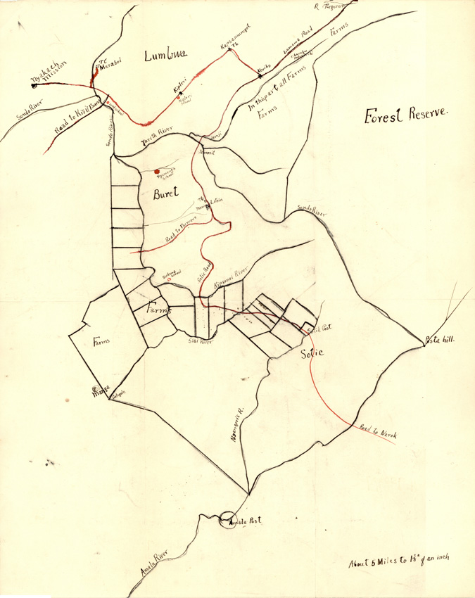
The map below depicts AIM’s mission station at Litein, Kenya, but further details about the map’s creator and date of creation remain unknown. Despite these mysteries, the map itself offers clues to the creator’s relationship to the Litein region and the document’s intended use.
The anonymous cartographer is especially concerned with documenting the location of local landmarks—rivers, roads, and particularly agricultural sites. While the map is carefully drawn and neatly labeled, the creator also used breezy generalizations, like “In this part all Farms.” At 13×16 inches, the map is small enough to be hand-held and was likely intended for internal use by the Litein Station staff members. Although the document does not include a key to explain the differences between the red and black ink roads or dots, it does highlight several AIM-related locations, including the “Nyakach Mission” on the far upper left corner and the “Amala Post” centered at the bottom of the document.
Fields and Stations of the Africa Inland Mission, 1895-1937
The following map, created by Africa Inland Mission in 1937, provides a fascinating glimpse into the Mission’s expansion and evolution in the 42 years since its founding in 1895. While the map includes expected political and topographical highlights, like national boundaries, capital cities, and significant bodies of water, the focus is overwhelmingly on sites of interest to AIM administrators and missionaries. Major cities like Nairobi, Mombasa, Dar es Salaam, and Addis Ababa are documented with miniscule dots and fine script, while AIM mission stations are underscored with oversized black circles and bolded text. The map also documents AIM’s strategic approach to evangelism and humanitarian work, with far fewer missionaries (226) and main stations 50) than rural outstations (1,350) and indigenous evangelists (1,600).
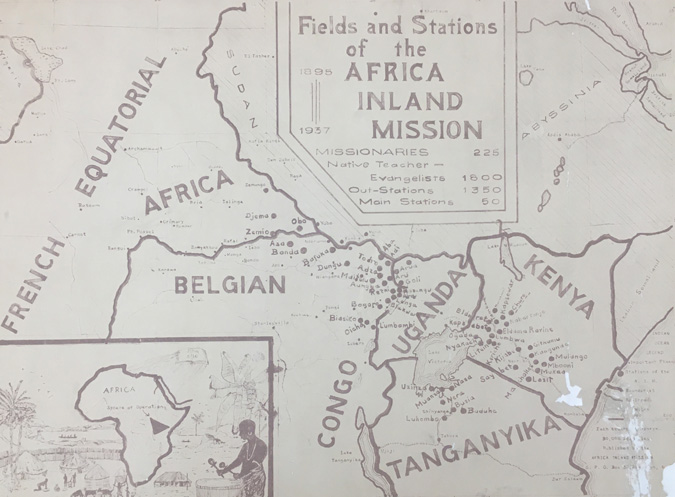
To researchers today, this map not only captures a piece of AIM institutional history but also serves as a tangible reminder of the reality of European colonialism in the mid-twentieth century and the ways in which Western missions agencies like Africa Inland Mission worked with and around those colonial governments. While this map captures only a small triangle of the African continent, the East African nations and regions it depicts are a sobering reminder of the oppressive presence of European powers—France, Belgium, Great Britain, Italy, and Germany—poised on the brink of global conflict in 1937.
Africa Inland Mission, 1944
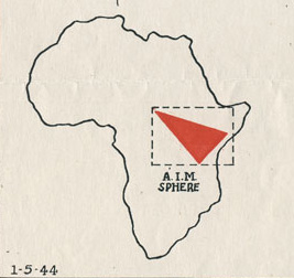
The map of AIM activity in East Africa below is a useful counterpoint to the 1937 map just above. Created only seven years apart, this version showcases the same geographical area but introduces several new navigational features in the key below the title. Specifically, this map identifies established, new, and projected AIM missions stations as well as significant cities, national borders, and bodies of water. This map is also the first to identify major railroads. A bold red triangle highlights the boundaries of current AIM work in 1944, stretching from Kenya Colony to French Equatorial Africa and only skimming a northernmost wedge of Tanganyika Territory.
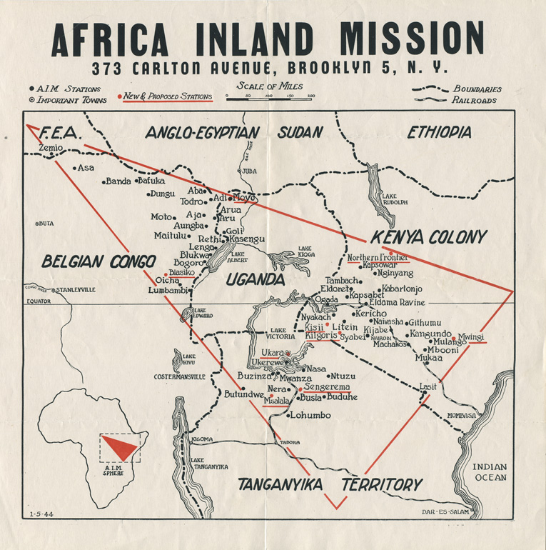
A 1944 map depicting the location of Africa Inland Mission stations, projected activity, and the extent of its many local operations. Item located in Collection 81, Oversize Folder PC29.
This map also reflects changes in the mission’s stateside administration by including the address of AIM’s North American Home Council, now headquartered in Brooklyn, New York, where it remained until 1969. The exact date stamp in the bottom left corner—January 5, 1944—also reflects the mission’s attempt to capture AIM’s current foci of service and plans for future expansion in a rapidly shifting landscape during World War II.
Africa Inland Mission, 1975
The map below jumps ahead three decades in our AIM timeline, showcasing both significant shifts in the political landscape of post-war East Africa, as well as Africa Inland Mission’s expansion beyond its previous red triangle boundaries in 1944. Entirely new nations appear—Rwanda, Burundi—while others maintain their historic boundaries but trade in national names for titles reflecting the postcolonial era, like the Central African Republic, Sudan, Zaire, and Tanzania.
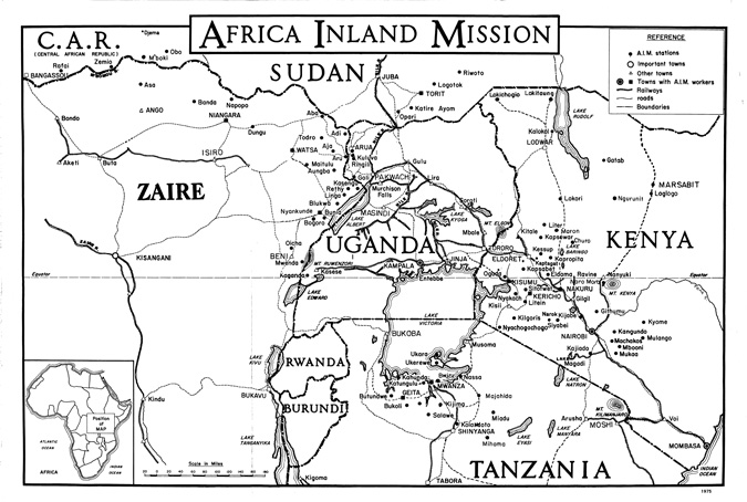
While this 1975 map may not have the aesthetic or visual appeal of previous editions, it remains a seminal reference point our archival team when processing collections relating to AIM or the history of missions in East Africa. In particularly, archivists frequently reference this map when determining the names of cities, towns, regions, and other topographical features mentioned by staff and missionaries in correspondence, reports, and meeting minutes in the AIM records as well as our expansive oral history collections. The map has also proved useful for tracing how titles and names in a myriad different African dialects are transliterated in English over decades.
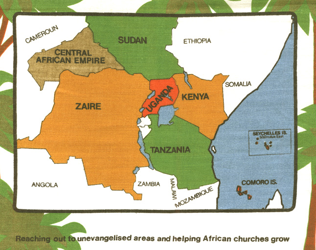
Africa Inland Mission, late 1970s
This final map is an excellent example of melding form and function, eschewing an oversize paper-based medium for a durable textile format. Designed as a colorful tea towel on white “Irish linen,” this map serves a dual purpose, merging a practical household items with marketing strategy. The towel illustrates in bold colors AIM’s current ministry sphere (notice that the Seychelles and Comoros Islands have been added since 1975) and proclaiming AIM’s mission statement: “Reaching out to unevangelized areas and helping African churches grow.” It is possible that functional map-towels like this one were given to AIM supporters in the United States as a tangible reminder to pray for AIM missionaries and ministry efforts.
The Archives has held materials from Africa Inland Mission since 1979, receiving additional donations over the past four decades. The official records of the Mission are complemented by the Archives’ extensive series of oral history interviews with AIM staff and missionaries. The AIM records remain a treasured and highly-used collection at the Wheaton College Billy Graham Center Archives, used by historians, anthropologists, missiologists, theologians, genealogists, and the general public for a wide variety of research projects and personal interest. To date, Collection 81: Records of Africa Inland Mission, International remains the Archive’s most requested collection.
